<- Rentals
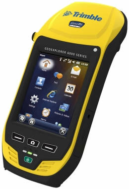
Trimble GeoExplorer 6000 Series GeoXH
For utility companies, municipalities, environmental management agencies, and many other organizations, timely accurate GIS field data is paramount to good decision making. The Trimble GeoExplorer 6000 series handheld is the best high accuracy hardware platform for any organization needing to map information precisely.
In conjunction with a Trimble Mapping & GIS field software application or a custom application developed by a Trimble Mapping & GIS Business Partner, the GeoExplorer 6000 series handheld is the ideal platform for:
For information call 1-866-672-0269 or e-mail sales@ritech.us
Trimble GeoExplorer 6000 Series GeoXH
For utility companies, municipalities, environmental management agencies, and many other organizations, timely accurate GIS field data is paramount to good decision making. The Trimble GeoExplorer 6000 series handheld is the best high accuracy hardware platform for any organization needing to map information precisely.
In conjunction with a Trimble Mapping & GIS field software application or a custom application developed by a Trimble Mapping & GIS Business Partner, the GeoExplorer 6000 series handheld is the ideal platform for:
- Utilities: Underground asset mapping and inspection, water network modeling, as-built mapping of lines/cable installations, and incident/outage reporting.
- Local government: High-density urban asset mapping, underground asset relocation, municipal asset inventory and inspection.
- Environmental management: Weed management, water debris management, pollution mapping, environmental incident mapping, sample gathering, agricultural subsidy determination.
For information call 1-866-672-0269 or e-mail sales@ritech.us
GENERAL SPECIFICATIONS |
||
|
| FEATURES | ||
|


