Sensors
When the operation requires more than just a visual assessment, RIT can provide a broad range of sensor options to provide the required data.
RIT has many more sensors available, contact us for more details.
When the operation requires more than just a visual assessment, RIT can provide a broad range of sensor options to provide the required data.
RIT has many more sensors available, contact us for more details.
LIDAR
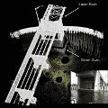
Utilizing our Leica Laser scanning systems, RIT has the equipment and expertise to create 3D as-builts of existing infrastructure.
Utilizing our Leica Laser scanning systems, RIT has the equipment and expertise to create 3D as-builts of existing infrastructure.
Sonar
Our numerous sonar platforms give RIT the ability to create detailed maps of subsea structures.
Our numerous sonar platforms give RIT the ability to create detailed maps of subsea structures.
Pipeline LIDAR
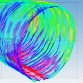
RIT's Pipeline LIDAR generates a high precision 3D model of the entire length of pipeline, allowing easy detection of warping and damage.
RIT's Pipeline LIDAR generates a high precision 3D model of the entire length of pipeline, allowing easy detection of warping and damage.


